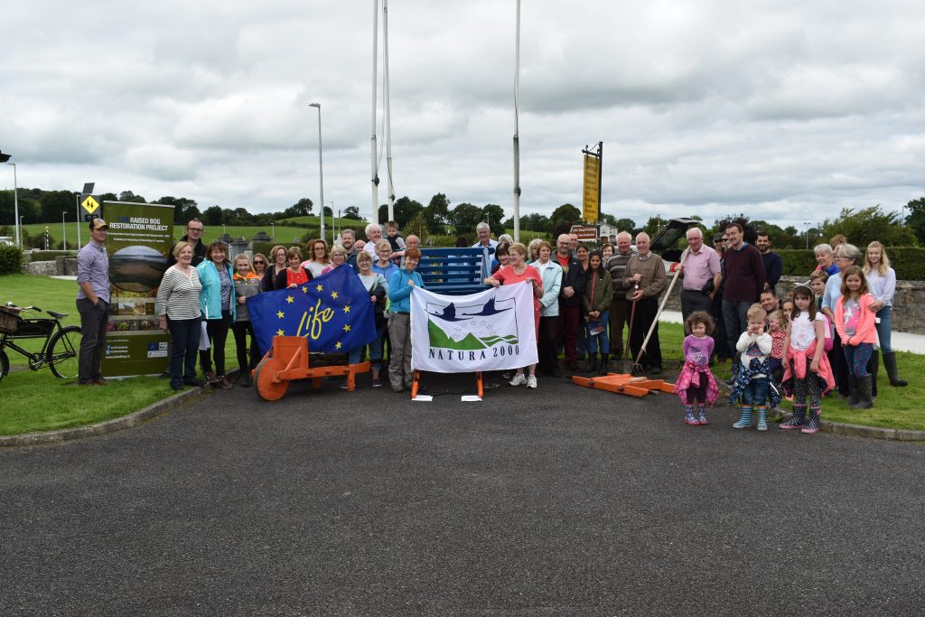
The Living Bog is actively working in the local communities surrounding our sites to collate as much information as possible about our bogs, and to record the local stories about the local bog that otherwise may well be lost in the passage of time. What is ordinary to those who may have lived there, or who heard stories or local folklore may well be extraordinary to those from elsewhere.
With that in mind, we asked Seamus Crawley of the Gortaganny Development Association to raid his own personal archives, and with the help of Seamus Kenny the following contains some extraordinary local history: Evidence of an important Togher Road (then and now) and of spuds in the bog! Enjoy!
The general area of west Roscommon and east Mayo extensive area is primarily that of a mix of arable land and bogland with a number of interspersed lakes. All records allude to lake connectivity via streams, rivers and indeed underground water passages/streams often referred to as ‘sinking rivers’. The landscape and associated quality is noted as been influenced by the extensive limestone content and turloughs in the area.
As regards the bogland specifically in the area, a feature of the general landscape is the mixture of arable lands in more elevated areas with drumlin-like, or esker-like, features. As regards the bogland itself, it is likely that the extensive bog areas were manipulated by ancestral populations over many years.
While noting that detailed archaeology studies could confirm much greater information, there are a couple of initial research examples that are worthy of further investigation.
-
TOGHER ROAD
In the late 18th and early 19th century in a pre-famine Ireland, extensive land and mapping surveys were conducted around West Roscommon. Some of the surveys were conducted by legislators, ordinance officers or, in many cases, by local landlords.
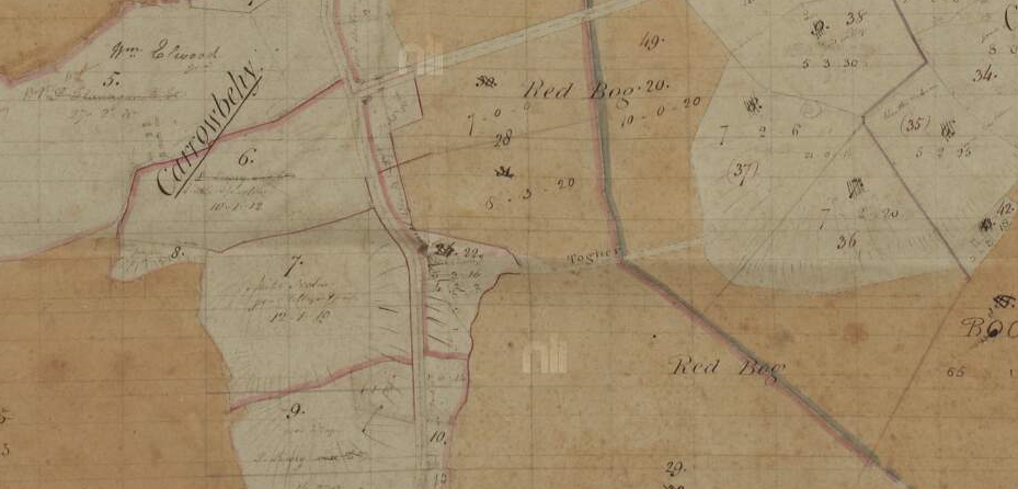
Below is a copy of a more extensive map survey area of Carrowbehy district (from National Library archives) which record a ‘Togher Road’ clearly defined between the land mass area of Cahir and Carrowbehy, between the old ‘Red Bog’ names of the bog.
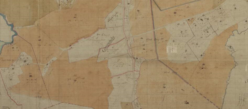
The survey was conducted in March 1830 and compiled in subsequent weeks. This road is typical of a likely location of a ‘togher’ which were extensively used and improved by local farmers in the Bronze Age and into the pre-Christian Iron Age.
The purpose of these trackway types made of wood was simply as a suitable method of passing undrained marshy land masses. The most intriguing detail relevant to the recording of this togher road is that it was recorded in the respective survey and may suggest that it maybe still in use or at the very least it still left a mark on the local landscape. Indeed, it may be probable that the ancient trackway was modernised by the use of stone and elevated to some extent accordingly. You can see it marked more clearly below.
Regardless, the fact it was recorded and where it was located opens up a great opportunity for research purposes relative to this ‘togher’ location and indeed the likelihood of more of this trackway type around Carrowbehy bog. The actual topography of this road and map area could easily suggest the most likely locations of other ‘Togher’ road types in Carrowbehy bog.
WHERE IS IT TODAY?
From the outset, the most relevant concern that needs to be examined is ‘where is this road today?’ Firstly, the march of subsequent progress in the district may offer a likely possibility. Noting that this map was a pre-famine survey, the more modern link road from Ballyhaunis to Loughglynn was improved in circa 1860s. This new road would have crossed this Togher road. The concern may be that any material on this Togher road may have found its way on to the new improved road. It is worth checking in any case!
(Also note that this map of 1830 does not record the ‘New Line’ road in Erritt. This may suggest that this road was most likely constructed in the 1830’s)
The Living Bog had a go at layering maps, with thanks to the OSI for allowing us to use their online maps. We overlayed the 1830’s map onto a current aerial view.
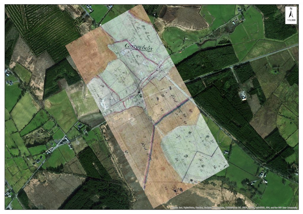
An overlay of the historic map onto a more recent OSI map.
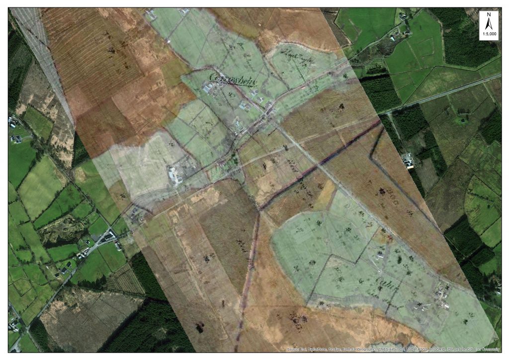
Using OSI maps, here is another look at the two eras with the Togher Road in the centre of the photo.
From overlaying the old maps onto more recent aerial imagery, it’s clear the ‘path’ of the old Togher Road is still there, alongside some forestry. It has been covered over substantially in recent years, and if not dissolved or disappeared it may well be subsumed by the march of earth and growing bog.
What is interesting to see if how the landscape changed in this small area over the course of almost 200 years. Where turf was not cut by traditional means, the old ‘Red Bog’ was forested and later reclaimed and put into use as agricultural land. Much of Ireland’s bogland was afforested over the last 150 years, quite a bit with non-native trees. Other LIFE projects in Ireland have concentrated on removing some of this forestry with some degree of success.
If you look at a recent clean aerial shot (from Bing Maps), you can still see the line of the Togher Road (between the red arrows), despite the changes to the surrounding landscape.
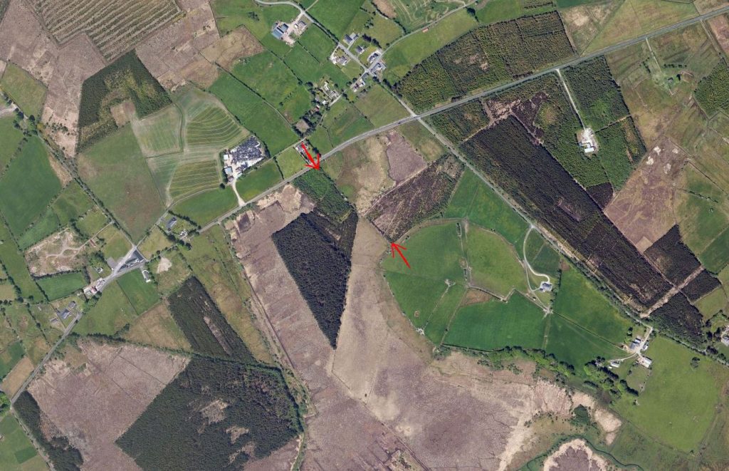
Aerial view from Bing Maps 2017: The area where the Togher Road was in indicated between the two arrows.
-
CULTIVATION OF BOGLAND aka ‘SPUDS ON THE BOG’
A more modern synopsis of farming practises in the 19th century notes the increased populations in West Roscommon and the country in general and the attempts to utilise bogland areas for more liveable and active agricultural purposes. This can be attributed to some marshy or cutaway lands that have been used for semi-arable farming and grazing purposes.
After the famine and the continual human burden of survival, the local steward of the Erritt Lodge estate conducted a research project in attempting to facilitate bogland area to grow potatoes of an acceptable standard.
Details attached from 1870 newspaper.
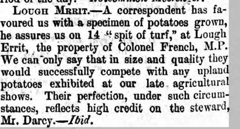
It is likely that this was a feature of both pre-famine and post famine activities in growing potatoes in bogland area. However, the attached detail seems to declare a more national newsworthy success in enabling the growth of potatoes!
This story adds to the extensive details recorded in both the Dillon and De Freyne estates in attempts in utilising bogland for more agriculturally productive requirements. Again, this detail is not of relevance to an ancient or medieval use of boglands, but it does illustrate ways that local communities tried to utilize and improve the use of boglands around Carrowbehy and district for more agricultural productive purposes in times past. (Other examples attained relevant to medical, conservation and lifestyle purposes).
UPDATE! November 9, 2017
Just as we posted this blog post on Nov 7th, a contract ecologist working for the Living Bog, George Smith of Blackthorn Ecology, just happened to be on Carrowbehy Bog undertaking some additional survey work. He had just come across a section of cut-over bog when he came upon a series of ridges, or lazy beds.
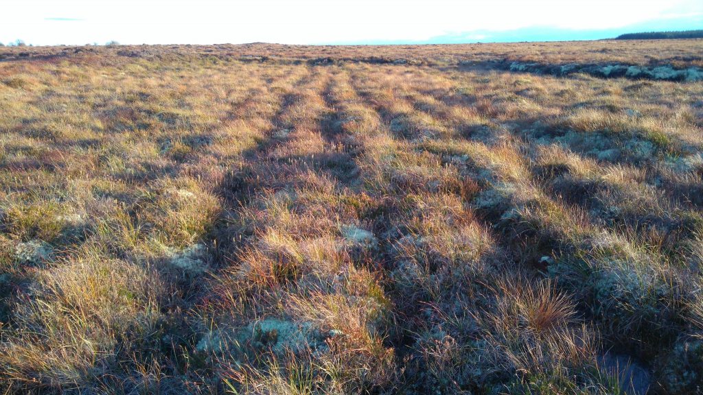
Lazy beds at Carrowbehy Bog SAC, photographed during survey work by George Smith, Blackthorn Ecology.
George says the series of ridges certainly seemed to be hand-dug, and were not the result of a machine on the bog. Peat extraction by machine did happen at Carrowbehy Bog SAC in the past, but it has been some time since machines were on the bog, and the presence of lichens and hummocks suggest these ridges have been there for some time.
George posted his pic to Twitter saying: “Lazy beds on cutover bog at the edge of Carrowbehy Bog. How desperate people must have been!”
Lazy beds on cutover bog at the edge of Carrowbehy Bog. How desperate people must have been! pic.twitter.com/upgetLxjPk
— Blackthorn Ecology (@BlackthornEcol) November 7, 2017
Are these the evidence of the ‘spuds on the bog’ experiment? Or did locals learn from it and attempt to grow their own spuds on the bog?
We’ll post an update soon….
-
MUSIC AND MYSTERY
When Seamus Kenny was collating the history and some stories for the Erritt Lodge book a couple of years ago, more stories emanated or in some cases some ‘heresay’ and rumours became more real after book completion!
As an example, more information on the French/Blake families in the district and the utilisation of Erritt Lodge for Feiseanna (Feis) in the early 20th century. Not alone was Jim Coffey and ‘Count’ John McCormack reputed to have visited the the Lodge, others such as acclaimed songwriter and performer Cathal McGarvey (Gaelic revivalist and writer of the ‘Star of the County Down’) is recorded to have performed at Erritt Lodge. Even more interesting is that a record exists of a photographer visiting a successful Feis at Erritt Lodge in the summer of 1907 and taking pictures with his Kodak camera!
Seamus also found details about the ‘White lady of the lake’… Keep checking into the website here for an update…
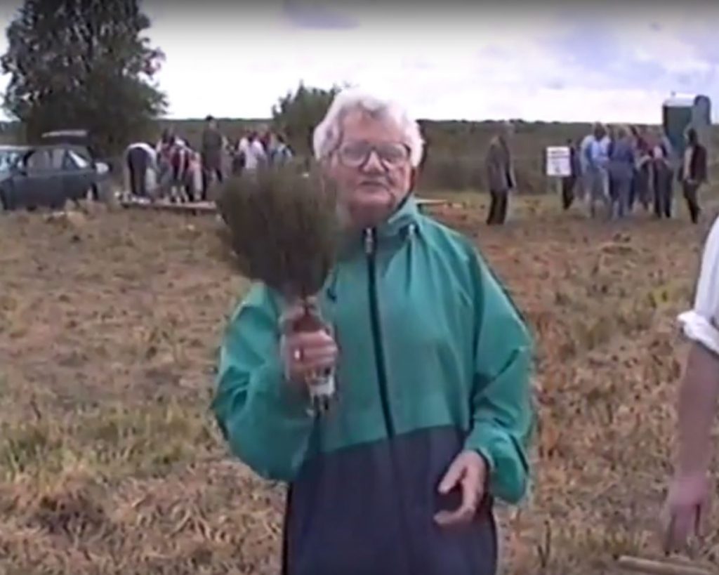
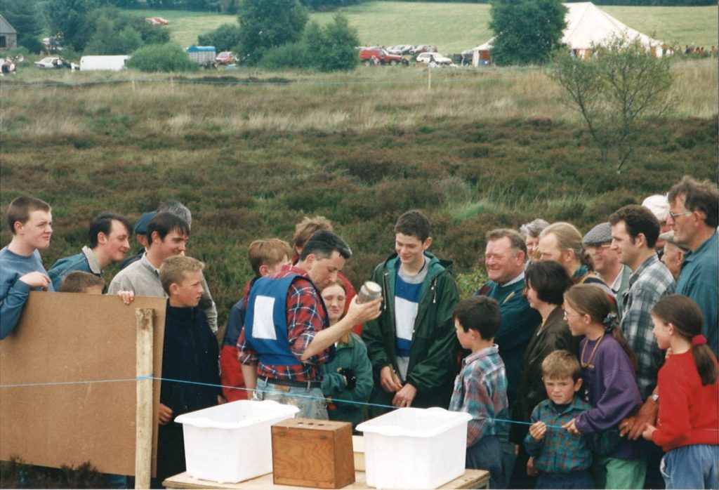
Cissy Tighe demonstrating Beesoms, or heather brushes during one of the original ‘Day on the Bog’ events on Killyconny Bog in the 1990’s.
Killyconny Bog was once upon a (recent) time home to a truly Irish occasion: the Mullagh ‘Day on the Bog’.
You can read more about it HERE in this archived IRISH TIMES article (please note: A subscription may be needed to read the article in full)
With thanks to local man Jim Smith of Rantavan, Mullagh, who has had a great interest in preserving Killyconny raised bog for many years, we present rare and restored footage of three of the great ‘Mullagh Bog Day’ community events, from 1997, 1998 and 1999.
The days were organised by the St Kilian Heritage Trust. The aim was to recreate the part the bog played in rural life and at the same time to heighten awareness of the importance of conserving as many as possible of our bogs for future generations. Each featured a packed programme of events, including:
• Guided tours of the bog
• Flora and Fauna talks
• Pond-dipping and Wildlife
• Exhibition of turf-cutting and turf-cutting competition
• Exhibitions of tools used on the bog – from the slean to barrows to bog crafts to heather ‘beesoms’ (brushes)
• Mini-farm
• Traditional music and song
• Story-telling and comedy
• Irish dancing
• Refreshments, and much more…
We are very lucky that Jim filmed these events and the restored footage is here for generations to enjoy. If you see a familiar face and can help us identify everybody in the videos, please drop us a line, email ronan.casey@npws.gov.ie or phone 076 1002627 and we’ll endeavor to update the credits. The videos are property of Jim Smith. Feel free to share on social media to give the Diaspora of Cavan and Meath a great window to our recent past.
1997
1997 was the first year of the Bog Day and it was a historic one for Cavan, as they beat Derry to become Ulster Champions! The bog event was great craic, as Jim’s video below details, and later on in the video, some of the Cavan team come to Mullagh with the trophy, and wild celebrations ensue on both the bog and on the streets!
1998
1998 saw the event grow, and it was a huge success with a big crowd enjoying the very best Mullagh had to offer. There was plenty to see and do, and the importance of preserving the bog and restoring it became a reality and was much-talked about locally. 1998 was an historic year too as the bog was officially designated an Special Area of Conservation after Michael D Higgins had signed the Habitats Directive a year earlier.
1999
1999 was another great year for the Mullagh Bog Day, as Jim’s video shows the community really getting behind it. Sadly, despite the interest and the good weather the event was blessed with for its three days, it was to be the last staging of the event… for now…
2017
The event was resurrected by a committee featuring members of the LIFE team and St Kilian’s Heritage Council in 2017, when a smaller-scale staging took place on Saturday August 26, as part of National Heritage Week. This successful event will pave the way for bigger community events on the bog in the future.
A section of the large crowd which enjoyed a walk and talk on Killyconny Bog SAC during our ‘Mullagh Day on the Bog’ event for Heritage Week 2017
As reported on our BOG BLOG page, the event attracted a large crowd, with all aspects of the bog covered, from turf-cutting days to today’s restoration plans.
The day commenced with old turf-cutting equipment displays and talks at St Kilian’s Heritage Centre in Mullagh town, honouring the turf cutting past of the bog. A number of local elders spoke about the days on the bog before the large crowd was bussed out to Killyconny Bog SAC for a walk and talk by Ronan Casey and Jack McGauley. There was over 50 in attendance and more left waiting at the Centre such was demand! The crowds were not just local, with tourists from Asia, Great Britain and America, plus people from Derry, Dublin, Kells, Navan and Drogheda as well as local media (Anglo Celt) and Cavan County Council reps all enjoying an informative walk and talk along the edge of Killyconny Bog SAC. It is hoped the event will be built on for next year and there is considerable local community enthusiasm and involvement for it to grow.
Check out the photo gallery from the day here:


PICTURES OF OLD
With thanks to local man Brendan Clarke, here are some photographic memories of the original ‘Day on the Bog’ events, mainly 1998.
Locals in wonder as an ecologist talks them through the story of raised bogs during a Killyconny Day on the Bog in the 1990’s